Day 1 The day started with a welcome from Sister Karen Elizabeth, the Motherhouse Administrator for the Dominican Sisters of Mission San Jose. Sr Karen shared some archaeological history of the Convent site and invited us to walk around if we had the time. My first impression of the site was green: grasses, trees, flowers, and meditation areas set in garden rooms. It was very peaceful on a Saturday morning.

We picked a juniper tree as our site datum, hammered in a piece of rebar and marked it with a wooden stake. Setting up the instrument took most of the morning as we all got a chance to try and level it before starting to measure the angles for the site. Could I do it again? Well, maybe with some help. Using the Trimble XT 2005 GPS instrument with David seemed much more efficient and accurate.

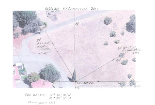
And then there are the field notebooks. I’m not quite sure what I’m supposed to be recording so I just took notes as we went along. From what I recorded I think I have the start of a site map. I downloaded the map from Google Earth, located our site datum and marked the angles. Am I on the right track?
 Day 1 The day started with a welcome from Sister Karen Elizabeth, the Motherhouse Administrator for the Dominican Sisters of Mission San Jose. Sr Karen shared some archaeological history of the Convent site and invited us to walk around if we had the time. My first impression of the site was green: grasses, trees, flowers, and meditation areas set in garden rooms. It was very peaceful on a Saturday morning.
  We picked a juniper tree as our site datum, hammered in a piece of rebar and marked it with a wooden stake. Setting up the instrument took most of the morning as we all got a chance to try and level it before starting to measure the angles for the site. Could I do it again? Well, maybe with some help. Using the Trimble XT 2005 GPS instrument with David seemed much more efficient and accurate.
  And then there are the field notebooks. I’m not quite sure what I’m supposed to be recording so I just took notes as we went along. From what I recorded I think I have the start of a site map. I downloaded the map from Google Earth, located our site datum and marked the angles. Am I on the right track?
Bravo on the site map draft Sandra.
ReplyDelete